
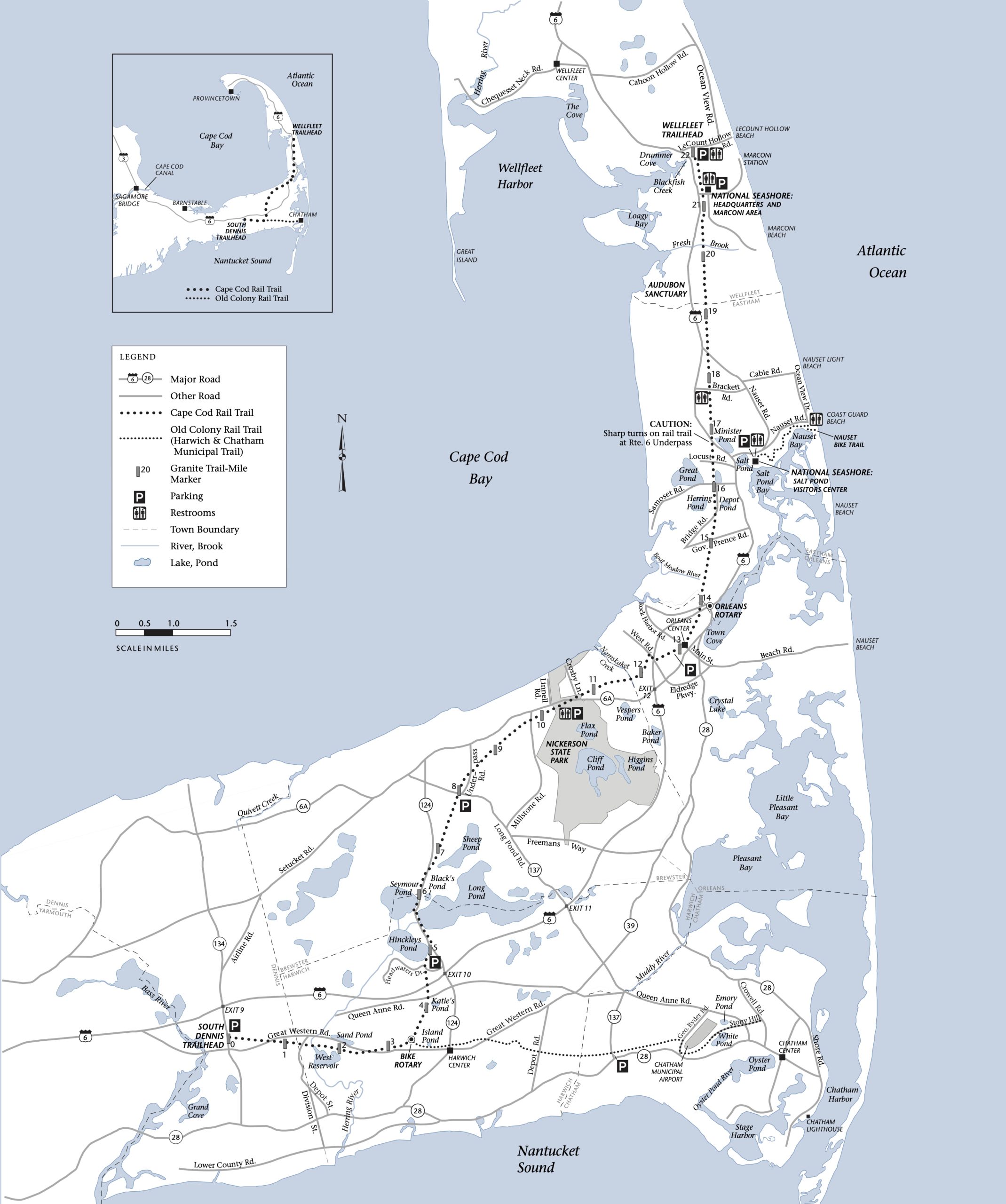
Cape Cod Rail Trail
Enjoy scenic views along the 22 mile paved trail with bikes, roller blades, and more. Ride, walk or run through 6 Cape Cod towns as you follow the Cape Cod Rail Trail. There’s plenty to see along the 25-mile trail and state and national parks to visit as you please.
Hours for Cape Cod Rail Trail: Sunrise to sunset
Parking at Cape Cod Rail Trail
Parking at Nickerson State Park charged Memorial Day through October 31
MA resident $5
Non-MA resident $20
Free parking for trail users is available at:
- Trailhead at Stations Avenue, South Yarmouth
- Trailhead at Route 134 in South Dennis
- Headwaters Drive in Harwich
- Route 137 in Brewster
- Orleans Center
- Cape Cod National Seashore at the Salt Pond Visitors Center in Eastham (1/2 mile from the Locust Road intersection with the trail)
- National Seashore at Marconi Area
- Trailhead at LeCount Hollow Road in South Wellfleet
Eastham
Aschetino Property Walk
(1.5 hours, easy) Walk through two of Eastham’s treasured town properties, the South Eastham Conservation Area and the Aschettino Property. You’ll pass through diverse landscapes of forest, with some very old “specimen trees,” marsh, and the historic Jeremiah’s Gutter. Take South Eastham Street (on the west side of Route 6) to Arrowwood Drive, turn left at Peach Orchard Lane.
“The Sea Has Many Voices” Coast Guard Beach
(2-3 hours, beach walking) Lend your ears to the voices of the wind, waves, and wildlife along the shore at Coast Guard Beach in Eastham. Explore the constantly changing shoreline, adaptations for survival, and ecological changes that have impacted this beach for years. Start at Cape Cod National Seashore Park Ranger at Coast Guard Beach parking lot.
Lamont Smith Conservation Area
Enjoy a loop trail in pine/oak woods and blueberry swamp. Parking at end of Peach Orchard Lane, from Route 6 via South Eastham Street and Arrowwood Drive.
Cottontail Acres Conservation Area (abuts Herring Pond)
Walk a 1/2 mile trail through meadows with stands of pine, oak,and red cedar. Parking at corner of Samoset Road and Lawton Road.
Wellfleet
Goose Pond to Try Island
(2 miles, easy) Stroll and explore the Wellfleet Bay Wildlife Sanctuary’s Goose Pond Trail out to Try Island. Travel through pine woods, heathland, salt marsh, freshwater wetlands, and an “old-growth” oak/hickory forest. Bring binoculars and comfortable walking shoes. The Wellfleet Bay Wildlife Sanctuary is located off Route 6 in South Wellfleet, just north of Eastham and Wellfleet town line, on the west side of the road.
Wellfleet Wanderer
(2-3 hours, easy) Explore the back roads and fire roads of the Wellfleet area, passing through varied landscapes from kettle ponds to ocean cliffs. Take Route 6 to Wellfleet, turn right onto Long Pond Road, and go approximately 1 mile.
Great Island
(4 hours) Walk as far as possible towards Jeremy Point. Bring lunch and water. From Rte. 6 turn left at light towards Wellfleet Center. Take a left at the dory on East Commercial Street to the harbor. Go right on Chequessett Neck Road and follow to the Great Neck Island parking lot on the left.
Truro
Pamet Marsh
(1.5 hours, easy) View the flora and fauna of Pamet Marsh. Wear waterproof shoes in case it’s damp. Park at 97 North Pamet Road in Truro.
Bay to Shore
(5 hours, 11 miles, strenuous) Hike from the shore of Cape Cod Bay, up and down the hills and hollows of Truro, to the cliffs of the Atlantic Ocean. Bring lunch and water. Take Route 6 to Prince Valley Road, turn left and go to end, turn right onto Old County Road, then immediately left onto Ryder Beach Road. Drive to end and park at lot.
Orleans
Namequoit Bog
(1 mile, easy) Walk through an abandoned cranberry bog and Atlantic White Cedar swamp to view birds and wetland plants. Must be able to leap ditches; poision ivy and tick protection advised. Begin at Pah Wah Point at the end of Namequoit Road east of Route 28.
Brewster
Wings Island
(2 hours) Explore coastal salt marshes and dune systems as well as discuss maritime communities along the coast. Route 6A.
Eagle Point to Seymour Pond
(2.5+ miles, moderate) Walk the newly marked trails in the heart of the beautiful oak/pine forests of the Punkhorn Parklands. Sweeping views of Upper Mill Pond and Seymour Pond. From Stony Brook Road, take Run Hill Road and follow until road turns to dirt. Park in lot on left.
“Indians and Farmers” at Nickerson State Park
(2+ miles, moderate) Go back in time on a woodland walk and cultural tour of the park. Start at the Flax Pond picnic area in Nickerson State Park, Route 6A.
“Sight Flight to Eagle Point” through Punkhorn Park
Enjoy easy walk through the Punkhorn. Begin at the Punkhorn parking lot at the end of Run Hill Road.
Sunset Walk and Picnic at Crosby Landing Beach
Bring a picnic, waterproof shoes, flashlight, and an extra windbreaker. Take Route 6A in Brewster to Crosby Lane, almost across the street from the entrance to Nickerson State Park. Follow Crosby Lane to the Landing Beach parking lot.
Harwich
Monomoy River Walk
Hike through 42 acres of rolling woodland on nearly one half-mile of Monomoy River (Muddy Creek) shoreline in the Pleasant Bay estuary. From Rt. 39, take Bay Road one mile east to parking area on the right, opposite Blue Heron Landing.
Lee Baldwin Memorial Walk in Punkhorn Park
(easy) Bring poetry and goodies to enjoy on the hilltop in honor of the love of nature. From the west: Take Route 6 to Exit 9 North (Route 134), proceed to Airline Road that forks off on the right. At the first intersection (flashing yellow light), take a right onto Old Chatham Road. At the stop sign at Depot Street/Slough Road, go straight, the road is now called Factory Road. Go to the end by the cranberry bog and park. From the east: Take Route 6 to Exit 10 (Route 124). Take a left heading south on Route 124, proceeding to stop sign at Queen Anne Road. Take a right, proceeding to stop sign at the merging onto Old Main Street. Continue on Old Main to stop sign at Depot Street. Take a right, until you go under the highway bridge, then take first right (Factory Road). Go to the end by the cranberry bog and park.
Chatham
Morris Island
(2 miles, moderate, sandy beach walking) Enjoy a walk through this wildlife preserve for excellent long views of South Beach, North and South Monomoy Islands, and three Chatham lighthouses. Follow Morris Island Road south from the Coast Guard Station and Lighthouse to the southern end of the causeway and park.
South Beach Seal Watch
(4 miles, moderate, sandy beach walking) Enjoy Chatham’s growing seal population. The seal population has grown significantly as the sand bars accumulate. Bring binoculars, hat, and water. Park along the south side of Bridge Street. Meet at the stairway to Lighthouse Beach.
Dennis
Crowe’s Pasture
(4 to 5 miles) Stroll through the Crowe’s Pasture, out to Quivett Creek, and then onto Coles Pond and the Town of Dennis’s newly acquired parcel of land. Bug spray is recommended, as are good hiking shoes, a light jacket, sunglasses, sun tan lotion, and sleeved pants and shirts. Remember to bring a snack, plenty of drinking water, and a camera. Start at the cemetery at the end of South Street in East Dennis where the dirt road into Crowe’s Path is located.
Yarmouth
Dennis Pond
(9 miles, moderate, hilly) Walk halfway around Dennis Pond through the Greenough Boy Scout Camp and the Yarmouth Historical Society Conservation Area. Bring lunch and water. Take Exit 7 off Route 6, head north on Willow Street. Go 0.25 mile and park in a small area on the right.
Historical Society of Old Yarmouth
(1.25 miles, easy). Enjoy a walk through forests and around kettleholes. Park behind the Yarmouthport Post Office on Route 6A.
Barnstable
Skunknet River in Osterville
(1 hour, easy) Take a woodland walk along streams and ponds and old cranberry bogs (enjoy the fall foliage here.) Start at the intersection of Bumps River Road and Pond Street, Osterville.
Bridge Creek Conservation Area
(1.5 hours, easy) Explore this beautiful forest, maple swamp, and cedar upland; a lot of variety in a small area. Follow Route 149 north of Route 6 (Exit 5) about 200 feet. Park at the green triangle just past the Congregational Church.
Long Pasture Walk
(2 miles, easy) Walk through old fields and evergreen forests to Sandy Neck overlook, then retrace steps through an abandoned hay pasture and woodlands. Take Route 6A to Cummaquid, turn north on Bone Hill Road at the sign for the Harbor Point Restaurant. Follow Bone Hill Road 1/8 mile to the Massachusetts Audubon Long Pasture parking lot on the left, where the road curves to the right.
Burgess Park Walk
Explore Burgess Park with views of Hamblin Pond and the Olmstead garden. Take Route 149 south from Route 6, Exit 5. The park is 2.6 miles on the right (or 1 mile north of Route 28 on the left).
Sandwich
Maple Swamp Conservation Area
(3 hours, 4 miles, moderate) Enjoy the varied terrain and kettlehole topography and be treated to a great view of Cape Cod Bay. Start at the parking lot off the Service Road between Exits 3 and 4 on the Mid-Cape Highway/Route 6.
Sandy Neck
(10-12 miles, 6 hours, difficult) Enjoy a day-long walk of a barrier beach. Bring binoculars, lunch, and lots of water. Park at the Sandy Neck Beach parking lot at the end of Sandy Neck Road, which is off Route 6A in East Sandwich.
Briar Patch Conservation Area
(1+ hour, moderately strenuous over uneven terrain) Enjoy a late afternoon slow stroll. This 58-acre property was purchased by the Town of Sandwich in 1974. A large granite boulder at the entrance is engraved with animal characters made famous by the writings of children’s author Thornton W. Burgess. October is perfect for viewing red maples and tupelos in all their fall glory. The Briar Patch trail circles the spectacular Smiling Pool wetlands alive with the sights and smells of fall on Cape Cod. Parking is provided at the Green Briar Nature Center just off Route 6A on Discovery Hill Road (approximately 6/10 mile west on Route 6A from Quaker Meeting House Road intersection). Look for Peter Rabbit on the large sign on Route 6A.
Bourne
Four Pond Conservation Area
(2 hours, 2-3 miles) Walk through this l33-acre conservation area and adjacent 3l2 acres of town forest. Learn about the 200-year history of the area and view habitats within salt marsh, woodlands, fresh water ponds, and natural springs. From the Bourne Rotary, go approximately 3.5 miles south on Route 28 and turn right onto Barlows Landing Road. Parking is 0.7 miles on the right.
Sagamore Hill Trail
(1.1 miles, leisurely) Enjoy a historical overview and walk to the breathtaking view at the summit, with a US Army Corps Park Ranger. From the Sagamore Bridge Rotary, take Meeting House Road towards Scusset Beach, continue past the park station, and park at the fish pier parking lot on the right.
Mashpee
Jehu Pond Conservation Area
(1.7 miles, moderate) Walk through the scenic pine/oak woodlands of the Mashpee National Wildlife Refuge to view salt marsh and beautiful Jehu Pond. Follow Great Neck Road South to Great Oak Road. Continue slowly past the first Jehu Pond sign to an area just past a New Seabury entrance sign. Look for a large dirt driveway on the right, turn into the drive, look for a Jehu Pond Conservation Area sign and a large parking area on the right.
Lowell Conservation Lands
(2 hours, easy). Enjoy this lovely conservation land. Start at the parking area on Sandwich-Cotuit Road. From Route 28 in Mashpee, take Route 130. Go 1 mile. Take a right onto Cotuit Road. Go 1.8 miles to Ryder Conservation Land Parking Lot on left. From Route 6, take Exit 3 south onto Quaker Meetinghouse Rd. At intersection go left onto Cotuit Road. Parking lot on right.
Santuit Pond
(4 miles, easy with one stream crossing) Stroll through parts of a 287-acre conservation area, one of the largest conservation areas purchased by Barnstable and Mashpee in 2002. Includes Mashpee Broom Factory, Makepeace Cranberry Bogs, herring run, site of first Indian church, 5,000-year old Wampanoag settlement, 100-year old forest, and more. From Route 28 in Cotuit, take Santuit-Newtown Road north for 0.75 miles. Turn left onto Hollow Road and park along the road.
Jehu Pond Conservation Area
(2 hours, 2 miles) Enjoy a walk along gentle trails. Start at the Jehu Pond parking area. Great Neck Road South from the Mashpee Rotary becomes Great Oak Road. Park on the right about 1 mile south of Red Brook Road.
Mashpee National Wildlife Refuge: Makepeace Sanctuary and Mercy Lowe Property
(2 hours, easy) Enjoy Orenda’s 136 acres, part of one of Cape Cod’s largest contiguous open space areas in the heart of the northern portion of the Mashpee National Wildlife Refuge. See improvements Orenda is making to this area to make it more accessible to the public for walking. You’ll visit Moody Pond and the Quashnet Bogs. Start at Mashpee Town Hall on Great Neck Road North in Mashpee to caravan to the site 2 miles away.
Falmouth
Long Pond Geology
(2 hours, 3.5 miles) Explore the geologic history of scenic Long Pond with you. From Main Street (Route 28) in Falmouth Center, take Gifford Street about 1.5 miles north. Goodwill Park is on left, opposite Saint Joseph’s Cemetery. Turn in between the large anchor chains.
Peterson Farm
Enjoy a working sheep farm, complete with border collies, many sheep, and a llama. Then proceed to a woodland trail and swamp/vernal pool area. Follow Woods Hole Road just about 1.5 miles south of Falmouth Center. There is parking off the road on the right side of the road; a large sign designates the farm.
Black Beach and Great Sippewissett Marsh
(2 miles, easy, sand) Enjoy these spectacularly scenic places. Bring binoculars to see late fall migrants and early wintering birds. From Route 28 go west 1 mile on Chapoquoit Road. Park at Chapoquoit Beach parking lot, West Falmouth.
Coonamesett Cranberry Festival and Walk along John Parker Bog
(1 hour, easy) Enjoy real cranberry harvest at an active cranberry farm. Walk along the Coonamesett River and John Parker Bog and learn about cranberry farming and the management team’s efforts to restore unique river, sandplain grassland, and pine barren habitats in Falmouth. Raptors may also be migrating. Take Routes 28 or 151 to Sandwich Road. Follow signs to John Parker Road and festival parking.
Crane Wildlife Area Geology Walk
(3 miles, 2 hours, a few steep hills) Enjoy natural history walk around Falmouth’s Crane Wildlife Area. Parking is on the north side of Route 151, just east of the Route 28 northbound on-ramp.